Snow and rain will return to the New York City area this week ahead of Christmas.
Our First Alert Weather Team has issued a First Alert Weather Day for Tuesday, as the conditions could cause some travel problems.
Snow totals late Monday into Tuesday
Following a sunny and cold day on Monday, a minor system is anticipated to bring another round of wintry weather to the region late in the evening into Tuesday morning.
With cold air still in place, accumulating snowfall is likely for many areas before a changeover to rain occurs.
CBS News New York 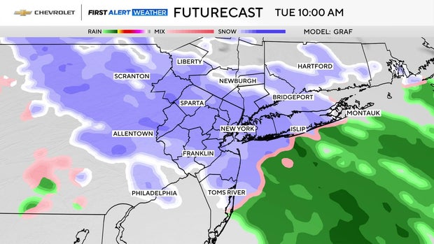
On average, snowfall totals will range from a coating to 2 inches, while northwestern zones may get 2-4 inches. As for coastal areas, there likely won’t be any accumulation.
Travel delays are probable, being that this little storm is coinciding with the very busy holiday travel period. After the storm departs, conditions look clear and calm for Christmas Eve. As for Christmas Day, a few showers are possible. Both days will feature high temperatures in the 40s.
Projected snowfall totals by region
New York City: coating to 1 inch
Long Island: coating to 1 inch
Central Jersey and Jersey Shore: coating to 1 inch
Northern New Jersey, Lower Hudson Valley, and Connecticut: 1-2 inches
Upper Hudson Valley and far Northwestern New Jersey: 2-4 inches
First Alert Weather maps